THE SWEDISH NATIONAL INFRASTRUCTURE FOR DIGITAL ARCHAEOLOGY (SweDigArch)
SweDigArch will construct and run the Swedish National Infrastructure for Digital Archaeology, catalysing a new generation of data driven research on human-environment interactions. It will facilitate the production of aggregated and harmonised datasets previously unmatched in scope, fulfilling demands for cutting-edge integrative, interdisciplinary research on long-term socio- environmental dynamics.
SweDigArch will be implemented through six modules: M1 will lead and coordinate the infrastructure; M2 will develop data aggregation functions and access through online interfaces and APIs according to FAIR principles; M3 will cover data from archaeological excavations and provide digitization pipelines; M4 will ensure the availability and integration of interdisciplinary analysis data from archaeological science; M5 will cater for cutting edge and future archaeological data, including photogrammetry, laser scanning, spectroscopy, imaging, molecular, synchrotron and neutron methods; M6 will ensure impact and societal value through communication, user support and outreach activities and stakeholder interaction.
DIGITAL ARCHAEOLOGY AND LANGUAGE DOCUMENTATION (DIAD)
Future generations will want to have maximally informative records of the past. Current digital technology has unprecedented potential to create such records. This platform will break new ground in cultural heritage documentation by initiating a comprehensive synthesis of two cutting-edge, but unconnected, fields: Digital Archaeology and Language Documentation. Through systematic conceptual, theoretical, and methodological exchange, the platform will set a new standard in the creation of digital cultural heritage records. It will pave the way for sustainable multimodal and multidimensional environments and workspaces which capture heritage with extraordinarily high resolution and broad scope. The platform bridges several conceptually fundamental divides, between the enduring and the ephemeral, tangible and intangible, static and dynamic, nature and culture, and past and present.
DOCUMENTING, INTERPRETING, PUBLISHING AND REUSING (PhD project)
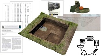
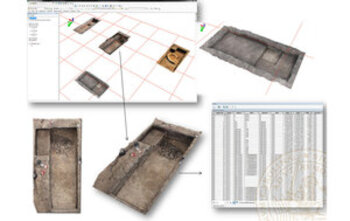
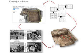
This project investigates how the application of targeted technologies could contribute to the definition of new forms of publication of archaeological investigations. It considers whether and how it is possible standardizing and optimizing the data management and publication work, embedding them into new forms of narration within the archaeological report. Despite the widespread use of innovative 3D data storage and management tools, indeed, text-and-image reports are still the main source of information on archaeological research, and it is quite difficult to access this kind of information by means different from the standardized one.The aim of this project is to design and develop dynamic working tools for archaeologists for both documentation and data post-processing and interpretation. This research will introduce new ways of sharing and accessing archaeological excavations taking advantage of the communicative potentials of the 3D contents and the web and the effective interaction between 3D models and their connected data.
MAPPING ENCOUNTERS: EXPERIMENTIAL ARCHAEOLOGY AND CRITICAL MAPPING (PhD project)
To understand the stories behind archaeological remains we must attempt to reconstruct the human-environment relationships that originally afforded them. In other words, as archaeologists we should try and think ourselves into the lifeworlds of our ancestors. Doing so within the theoretical and methodological confines of modern Western science, however, remains extremely problematic. This project focuses on the dynamic and multi-sensorial elements of experience that are especially ill-served by the conventions of modern Western cartography, and that stand to benefit greatly from alternative approaches to past human experience. More specifically, this research will examine the human experience in seascapes and timescapes, two particularly overlooked contexts of human-environment experience. Representation methods shall be selected based on their potential for exploring these experience environments, and will almost certainly include isochronic mapping, viewshed analysis and soundscape cartography, among others.
ARTIFICIAL INTELLIGENCE AND LANDSCAPE ANALYSIS; EXPANDING METHODS AND CHALLENGING PARADIGMS
In the last decade artificial intelligence has started assisting researchers in performing complex computational operations, providing scholars with the possibility to analyze datasets so far considered too large or too complex to be surveyed by humans. The exponential development and diffusion of new data-acquisition technologies, the expansion of the world wide web and the increased availability of large datasets of heterogeneous spatial geographic information, opened incredible opportunities for geo-scientists to explore and define novel investigation approaches. this project will develop an investigation approach based on the systematic training of highly intelligent machines for detecting scattered archaeological elements visible in different dataset.
GRIBSHUNDEN Shipwreck
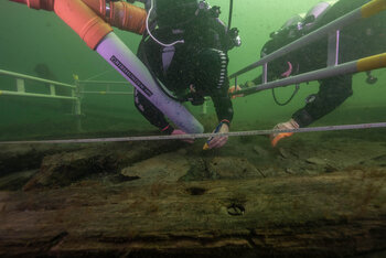
Excavation of flagship of Danish King Hans (1495) and analysis of artifacts from the site. GRIBSHUNDEN was built as a Ship of Discovery, similar to Columbus' SANTA MARIA. It was the first generation of sailing ship capable of carrying a battery of heavy guns, and was designed to project military and political power across great distances.
DYNAMIC COLLECTIONS
The recent development and use of 3D acquisition and visualization technology have contributed to the rapid emergence of a large number of 3D collections, whose production has been most often justified to trigger a process of data democratization and diffusion. Despite the fact that several 3D collections are now available online in different forms, it is not clear how those data (once stored) are used by other specialists (or non-professionals) to produce new knowledge. Is this data democratization process really taking place? And are the 3D models stored in these new archives capable of serving the needs of different specialists across the cultural heritage (CH) sector?
The development of such project will revolutionize the way specialists interact with archaeological material promoting best practice and quality in heritage and material studies.
BLUE ARCHAEOLOGY. ASSEMBLING THE CULTURAL AND NATURAL HERITAGE OF SUBMERGED STONE-AGE SEASCAPES IN SWEDEN
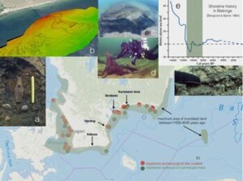
The project seeks to gain novel knowledge of the Early Holocene submerged landscapes of Southern Sweden. To do this, a research group from different fields has been formed; researchers from archaeology and the cultural heritage sector, GIS-and 3D-visualization specialists, bioarchaeologists, divers etc. During year 2 and 3 test excavations will be conducted. In order to assess degradation a unique sonar-mapping program will be employed.
3D GIS: A RESEARCH PLATFORM FOR THE DEVELOPMENT OF NEW RESEARCH METHODOLOGIES FOR THE DOCUMENTATION AND ANALYSIS OF ARCHAEOLOGICAL SITES
Goal of this project is the development of new methodologies for the systematic generation of 3D models in support of archaeological practice. In specific this research activity is focused in studying how the combination between 3D data and three dimensional Geographic Information Systems (3D GIS) increase the capacity of archaeologists to retrieve new archaeological interpretations.
UPPÅKRA RESEARCH PROJECT
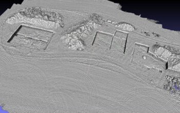
Since 2009 the team is employing different 3D acquisition techniques to record contexts and materials retrieved in the frame of the field archaeological investigation at the archaeological site of Uppåkra, Scania, Sweden. The methodology developed in the frame of this work allows for a 3D temporal simulation of the different materials retrieved during the years.
3D GIS AT ÇATALHÖYÜK
Through collaboration with Stanford University and Duke University, since 2011 we are testing 3D documentation techniques in the frame of the Çatalhöyük research project. In specific by combining image based 3D reconstruction techniques and 3D GIS to simulate the complex stratigraphic sequence detected on site, our work focuses in defining how the use of simulation systems impact the archaeological interpretation process.
USING HIGH PERFORMANCE COMPUTING RESOURCES FOR THE RECORD AND ANALYSIS OF CULTURAL HERITAGE SITES
This project aims at defining and testing new three-dimensional (3D) acquisition workflows of large cultural heritage sites employing High Performance Computing resources. This will allow to process onsite high-resolution raw data, recorded by means of close range photogrammetry and laser scanning.
ARKEOLOGISK INFORMATION I DET DIGITALISERADE SAMHÄLLET
The project addresses a series of significant recognised challenges within archaeology and, because of the broad societal implications of archaeological information from cultural heritage, museums and media industry to community planning in the digitalised society. In the frame of this research activity our work is focused in studying the implications that 3D models are having in the frame of field practice.
SPACE AND MOVEMENT IN A POMPEIAN HOUSE: THE CONTRIBUTION OF 3D GIS
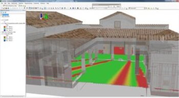
Main purpose of this project is to investigate the social dimension of space in Pompeii through the use of archaeological computing. 3D visual analysis techniques are used in support of traditional sources to generate new insights on the architectural settings of buildings, in order to test hypotheses about the way original inhabitants regulate the space. As a starting case study, the house of Caecilius Iucundus in insula V 1 has been chosen.
AN ANCIENT CITYSCAPE AND ITS PEOPLE – A STUDY OF ANCIENT HERMION
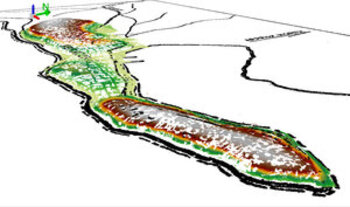
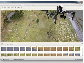
Aim of this project is to combine advanced acquiring techniques in order to re-construct the ancient topography of the city. In particular, a high/resolution Digital Elevation Model (DEM) has been produced by means of UAV technology and the obtained terrain put in relationship with some of the still visible archaeological features (temple basement, city walls, stone blocks) and everything implemented in a GIS platform.
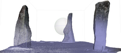
A 3D-MODEL AND A RECONSTRUCTION OF THE ORIGINAL EARLY HOLOCENE CAVE SEQUENCE OF STORA FÖRVAR
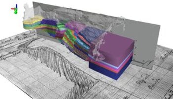
Purpose of this project is to take advantage of a combination of 3D laser scanning acquisition techniques, old archive documentation and 3D GIS platform in order to re-construct the original stratigraphic sequence as it was documented by archaeologists between the end of XIX and the beginning of XX Century. Additionally, the dataset obtained will be analyzed through advanced GIS-based techniques.
ILLUMINATION MATTERS: Revisiting the Roman house in a new light (PhD project)
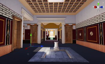
The aim of the proposed research, focused on the case study of the House of the Greek Epigrams in the northern part of the Insula V1 in Pompeii, will be to investigate how combined 3D digitizing techniques (laser scanner, image based modeling, 3D-GIS and predictive rendering) can support the archaeological interpretation. In specific, novel methods exploiting three-dimensional physically based and historically accurate lighting simulation and analysis will be explored in order to validate new interpretations and challenge previously established hypotheses about the existing relationship between social and spatial behavior in the Roman house.
THE NAHR AL-JAWZ PROJECT
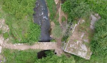
In the frame of a collaboration between DARK Lab, University of Copenhagen and University of Oxford we recently started an acquisition campaign in the Batrun district of Lebanon. As a part of an archaeological, historical and anthropological landscape study, we contribute to the general understanding of the research area through a combined approach that include UAV data capture, Image-based 3D modelling and laser scanning techniques. All the data are then implemented and analyzed in a 3D GIS environment.
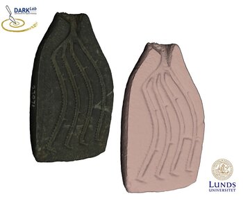
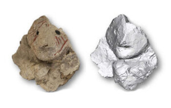
A 3D DIGITAL APPROACH TO THE STYLISTIC AND TYPO-TECHNOLOGICAL STUDY OF SMALL FIGURINES FROM AYIA IRINI, CYPRUS (PHD PROJECT)
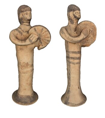
The research is aimed at enhancing the interpretation and analysis of cultural material through a multidisciplinary approach based on the integration of traditional archaeological studies and the development and use of a 3D digital approach. The study is applied to a sample of clay figurines found at the site of Ayia Irini (Cyprus), a cult sanctuary discovered by the Swedish Cyprus Expedition (SCE) in 1929 and dated from the the late Bronze Age to the end of the Cypro-Archaic period. The 3D geometry comparison of the statuettes is aimed at addressing aspects of manufacture and production: presence of rules, ratios, canons, use of same moulds tools and possible identification of specific artisans’ hands.