Technical Workflow Overview
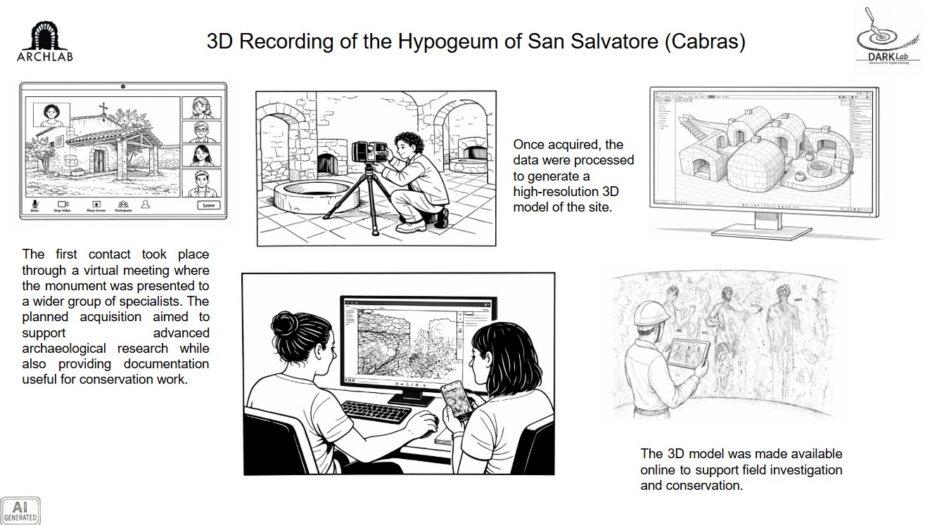
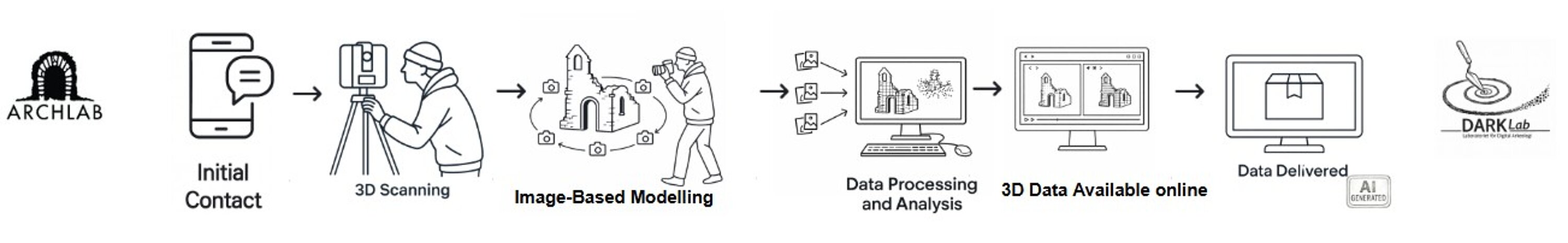
Following the initial contact with the Fondazione Mont’e Prama (https://monteprama.it/la-fondazione/), a series of meetings were organised to discuss the aims of the documentation campaign, clarify the research objectives, and define the acquisition strategy for the hypogeum of San Salvatore in Cabras, Sardinia, Italy. Particular attention was given to the architectural configuration of the site, which consists of a multi-chamber underground complex located directly beneath the church of San Salvatore. During the preparatory phase, the team defined the types of spatial data required and the instruments necessary to support both archaeological investigation and future conservation work.
The fieldwork was conducted over three days and involved the acquisition of high-resolution spatial data both inside the hypogeum and in the surrounding area of the church. The underground chambers were documented using a FARO phase-shift laser scanner mounted on a tripod, allowing precise capture of the geometry of the internal spaces. Additional scans were carried out within the church and in the immediate surroundings in order to connect the underground complex with the overlying structure and provide a broader spatial framework that would allow future users to easily georeference the dataset. In parallel, a photographic acquisition campaign was carried out inside the hypogeum to capture high-resolution colour information through image-based modelling.
After the field campaign, the processing workflow began with the registration of the laser-scanning datasets using FARO Scene. The registered scans were then imported into RealityScan, where they were combined with the photographic datasets produced during the image-based modelling campaign. Camera positions identified during the photogrammetric processing were integrated with the laser-scanning data to generate a hybrid three-dimensional model that combines the geometric accuracy of the laser scans with the high-resolution colour information derived from the images.
The resulting dataset represents a unified high-resolution 3D model of the hypogeum and its surrounding architectural context. All raw datasets, intermediate processing outputs, and final models were made available to the project. To facilitate access for researchers, archaeologists, and conservators, the models were also published through the Archaeological Interacting Report system (AIR), allowing the 3D data to be explored and reused through an online environment.
1- Phase-Shift Laser Scanning – FARO Focus
The hypogeum of San Salvatore in Cabras (Sardinia, Italy) was documented using a FARO Focus phase-shift scanner, mounted on a tripod to capture high-resolution spatial data of the underground architecture. The hypogeum consists of a complex multi-chamber structure located directly beneath the church of San Salvatore, requiring a systematic acquisition strategy to ensure full geometric coverage of the interior spaces.
A total of 105 scan stations were positioned throughout the chambers and connecting corridors to minimise occlusions and capture the architectural geometry of the underground structure. The laser scanner produced sub-centimetre resolution point clouds, enabling the accurate recording of curved walls, architectural features, and spatial relationships between the different chambers.
Additional scans were acquired inside the church and in the surrounding exterior area. This extended acquisition ensured that the underground complex could be spatially connected to the church above and provided a broader spatial framework that will allow future users to georeference the dataset and integrate it with other archaeological or conservation data.
2-Photogrammetric Recording – Image-Based Modelling
To complement the geometric precision of the laser scanning dataset, a photogrammetric acquisition campaign was carried out inside the hypogeum using high-resolution RGB photographs acquired from multiple viewpoints within the chambers.
The photographic dataset was designed to capture detailed colour information and surface textures that cannot be fully recorded through laser scanning alone. This aspect was particularly important because the monument preserves several mural paintings whose colour and pictorial details required accurate visual documentation. Particular attention was therefore given to documenting wall surfacesand painted areas with complex geometry, ensuring sufficient image overlap and coverage for reliable photogrammetric reconstruction.
These images were processed using RealityScan, where camera positions were automatically identified and used to generate a detailed image-based 3D reconstruction of the hypogeum. The resulting photogrammetric dataset provided high-quality colour textures and additional geometric detail, complementing the laser-scanning data and supporting the creation of a visually accurate representation of the site.
3-Scan Registration – FARO Scene
Following the field acquisition, the raw point cloud datasets generated by the FARO Focus phase-shift scanner were processed and registered using FARO Scene, the proprietary software designed for managing and aligning FARO laser-scanning data.
During this stage, the individual scans acquired from the 105 scan stations were aligned and merged into a unified spatial dataset. The registration process involved identifying overlapping areas between adjacent scans and accurately positioning them within a common coordinate framework. This ensured the correct spatial alignment of the different chambers of the hypogeum as well as their connection with the scans acquired inside the church above and in the surrounding exterior area.
The resulting registered point cloud represents a continuous high-resolution three-dimensional record of the entire architectural complex. This integrated dataset served as the geometric foundation for the subsequent processing stages, including photogrammetric integration and hybrid model generation.
4-Hybrid 3D Integration – RealityScan
The final three-dimensional model of the hypogeum was generated through the integration of laser-scanning and photogrammetric datasets within RealityScan.
The laser scans, previously registered using FARO Scene, were imported into the processing environment and used as the primary geometric reference for the reconstruction. The photogrammetric dataset was then aligned with the laser-scanning data using the camera positions calculated during the image-based modelling process.
This workflow produced a hybrid 3D model that combines the strengths of both documentation techniques. The laser scanner provided highly accurate spatial geometry and structural consistency, while the photogrammetric reconstruction supplied detailed colour information and surface textures.
By merging these complementary datasets, the final model achieved both metric reliability and visual realism, enabling accurate documentation and interpretation of the hypogeum's complex spatial configuration.
5-Spatial Context Documentation – Church and Surroundings
In addition to documenting the underground chambers of the hypogeum, the acquisition campaign extended to the church of San Salvatore and its immediate surroundings. This broader documentation strategy was designed to place the underground complex within a coherent spatial framework and to facilitate the future reuse and georeferencing of the dataset.
Laser scans were therefore acquired inside the church and around the external perimeter of the building. These additional datasets established a spatial connection between the hypogeum and the architectural structure above it, allowing the underground chambers to be accurately positioned in relation to the visible monument.
By documenting both the subterranean and surface components of the site, the resulting dataset provides a multi-scale representation of the archaeological context. This approach enables future researchers and conservation specialists to integrate the 3D documentation with other spatial data sources and to situate the hypogeum within the broader architectural and landscape environment of San Salvatore.
6-Online Publication – AIR (Archaeological Interactive Report)
Once processing was completed, the final 3D models were made accessible through AIR – Archaeological Interactive Report, a digital platform developed at Lund University to support the dissemination and reuse of archaeological documentation.
The AIR environment allows the 3D datasets to be explored through online visualisation tools, enabling researchers, archaeologists, and conservators to interact directly with the models without requiring specialised 3D software. Users can examine architectural features, navigate the reconstructed spaces, and access the digital documentation through a web-based interface.
By publishing the dataset through AIR, the project ensures that the documentation of the hypogeum of San Salvatore remains accessible, reusable, and suitable for future research and conservation activities, while supporting collaborative interpretation and long-term digital preservation.