
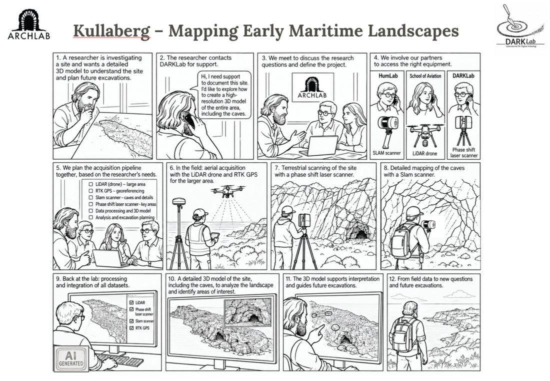
Technical Workflow Overview
The Kullaberg project provided an opportunity to develop a multi-scale spatial documentation workflow in direct response to an ongoing archaeological research project. The investigation required detailed 3D documentation of archaeological sites and their surrounding landscape, including caves and other areas that are difficult to record using a single acquisition method.
Following discussions with the research team, DARKLab worked together with the Lund University Department for Aviation and Aeronautical Sciences and the Humanities Laboratory to define an acquisition strategy based on the project's research questions. Rather than selecting a single recording technology, the workflow combined several complementary methods operating at different spatial scales. This approach reflects ArchLab's model of expert support, in which methods and acquisition strategies are selected according to the requirements of individual research projects.
Large areas of the landscape were documented using drone-based LiDAR, supported by differential GNSS measurements to provide an accurate spatial reference. Terrestrial phase-shift laser scanning was used to record selected areas at higher resolution, while a SLAM scanner allowed rapid documentation of caves and other complex spaces where conventional terrestrial or aerial acquisition is more difficult. These methods correspond closely to the spatial documentation, remote-sensing and multi-scalar 3D capabilities developed within ArchLab Module 8.
After fieldwork, the datasets were processed and integrated within a common spatial framework. The resulting 3D dataset connects landscape-scale documentation with detailed records of individual archaeological features and caves. Researchers can therefore move between different spatial scales within the same digital environment, examine relationships between archaeological remains and the surrounding terrain, and identify areas requiring closer investigation.
The 3D documentation is not intended simply as a final representation of the site. It forms part of the research process and can continue to support interpretation as the project develops, helping researchers formulate new questions, identify areas of interest and plan future fieldwork and excavation. This follows the broader ArchLab approach of connecting project design, data acquisition, analysis and subsequent interpretation through continuous expert support.

1 — UAV LiDAR – Landscape-scale recording
Airborne LiDAR was used to document portions of the landscape surrounding the archaeological areas investigated at Kullaberg. The system was operated by the Department for Aviation and Aeronautical Sciences and provided a dense three-dimensional point cloud covering terrain, vegetation and visible archaeological features.
The main advantage of airborne LiDAR in this context is its ability to record large areas efficiently while preserving detailed information about topography. Because individual laser pulses can generate returns from different levels within vegetation, the resulting point cloud can be classified to separate ground from vegetation and other objects. This makes it possible to generate a digital terrain model in which subtle variations in the underlying surface can be examined independently of much of the vegetation cover.
The timing of the acquisition is an important part of the survey strategy. Although LiDAR can record ground points through gaps in vegetation, the density of foliage affects how many laser pulses reach the ground. Surveying during periods of reduced vegetation cover therefore improves the representation of the terrain, particularly in wooded areas. Seasonal conditions, weather, wind and visibility also have to be considered when planning UAV operations.
At Kullaberg, survey planning also had to account for the protected character of the landscape. UAV operations were coordinated in advance with the relevant authorities and planned around local conservation requirements and seasonal conditions. The UAV acquisition was therefore planned in advance in relation to these restrictions and carried out under the relevant permissions and in coordination with the authorities and land managers responsible for the protected area. This formed an integral part of the fieldwork planning, together with the selection of suitable seasonal and weather conditions.
At Kullaberg, the resulting LiDAR dataset provides the large-scale spatial framework within which the more detailed terrestrial recordings can be interpreted. It allows archaeological sites and areas of interest to be examined in relation to slope, elevation, accessibility, coastal morphology and the surrounding terrain.
The UAV LiDAR workflow uses the DJI Matrice 300 RTK together with the Zenmuse L1 sensor, which combines LiDAR, an IMU and an RGB camera.
2 — Differential GNSS – Spatial control and georeferencing
Differential GNSS surveying was used to establish accurate spatial control across the study area. A Topcon HiPer XR GNSS receiver, provided by the Lund University Humanities Lab through GOLab, was used for this part of the survey.
Unlike the 3D recording instruments, the primary purpose of the GNSS system was not to generate a detailed representation of archaeological surfaces. Instead, it provided accurately positioned reference measurements that could be used to connect datasets acquired independently by different instruments.
This becomes particularly important in a workflow such as Kullaberg, where airborne LiDAR, terrestrial laser scanning, mobile SLAM scanning and photographic datasets operate at different scales and may initially use different internal coordinate systems.
Control points measured with differential GNSS therefore provide a common geographical framework. They allow individual surveys to be checked against external coordinates and facilitate their subsequent integration within GIS and 3D environments.
At Kullaberg, this spatial control was particularly important because the objective was not simply to produce isolated 3D models, but to understand individual archaeological areas in relation to the surrounding landscape.
3 — Phase-shift laser scanner – High-resolution static recording
A phase-shift terrestrial laser scanner was used where particularly dense and geometrically controlled documentation was required.
Unlike the mobile SLAM system, the phase-shift scanner operates from a series of stationary positions. From each position it measures millions of individual points on surrounding surfaces. Multiple scans are then registered together to create a continuous three-dimensional point cloud.
This approach requires more time in the field than mobile scanning, but produces dense and highly controlled geometric information. It is therefore particularly useful for documenting archaeological surfaces, rock formations, cave entrances and other areas where detailed morphology needs to be preserved.
At Kullaberg, the phase-shift scanner provided the high-resolution component of the terrestrial survey. Scan positions were selected to maximise overlap while reducing areas hidden from individual scanner positions by the complex topography.
The resulting point clouds can be examined directly, used to extract measurements and sections, or integrated with the other datasets acquired during the campaign.
DARKLab currently operates a FARO Focus Premium terrestrial phase-shift laser scanner. If this is the instrument used at Kullaberg, I would name it explicitly here as Phase-Shift Laser Scanning – FARO Focus Premium, exactly as you do on the Sundre and San Salvatore pages.
4 — SLAM scanner – Mobile recording of complex spaces
A CHCNAV RS10 handheld SLAM 3D laser scanner with GNSS RTK, provided by the Lund University Humanities Lab through GOLab, was used to complement the static phase-shift survey.
The RS10 combines mobile laser scanning with SLAM—Simultaneous Localisation and Mapping—and GNSS RTK positioning. This allows the operator to move through the survey area while the system continuously records the surrounding environment and estimates its trajectory, producing a three-dimensional point cloud without the need to work from a sequence of fixed scan stations.
This approach was particularly useful at Kullaberg, where rocky passages, irregular terrain, caves, and transitions between exterior and interior spaces can be difficult and time-consuming to document with a tripod-mounted scanner. Mobile scanning made it possible to record these areas continuously and relatively quickly.
The SLAM survey therefore served a different purpose from the phase-shift scanning. The phase-shift scanner was used where denser and more geometrically controlled documentation was required, while the RS10 provided rapid coverage of complex spaces and helped connect areas that would otherwise have required a large number of individual static scan positions.
The integration of GNSS RTK also offered an additional advantage in open areas, where the scanner trajectory could be tied more directly to an external spatial reference. In enclosed or partially covered spaces, such as caves or narrow rocky passages, the SLAM component remained essential for maintaining the continuity of the survey.
The two methods were therefore used together, each addressing different recording conditions within the site.
5 — Photographic recording – Visual documentation and image-based modelling
Photographic recording complemented the laser-based acquisitions by providing high-resolution colour information from selected parts of the site.
Laser scanning primarily records geometry. Although some laser-scanning systems can also acquire colour, dedicated photographs generally provide considerably better control over image quality and surface appearance. Photographs can therefore be used either as documentation in their own right or as input for image-based 3D modelling.
At Kullaberg, photographic acquisition was used alongside the geometric survey so that surfaces and archaeological features could be documented visually and, where appropriate, incorporated into the larger 3D dataset.
Images acquired with sufficient overlap can be processed through Structure-from-Motion photogrammetry to calculate camera positions and reconstruct surface geometry. They can also provide high-resolution textures for models whose principal geometry derives from laser scanning.
The photographic dataset consequently provides a bridge between metric three-dimensional documentation and the visual characteristics of the archaeological environment.
6 — Combining the instruments
The strength of the Kullaberg campaign comes from combining instruments with different acquisition characteristics rather than attempting to document the entire site using a single technology.
The UAV LiDAR establishes the wider topographic context. Differential GNSS provides the spatial control required to relate the different surveys to one another. Static phase-shift laser scanning records selected locations at high geometric resolution. Mobile SLAM scanning extends the survey efficiently through complex terrain and constrained spaces. Photographic recording adds detailed visual information and provides material for image-based modelling.
Once transformed into a common coordinate framework, these datasets form an integrated spatial resource that can be explored at different scales: from the surrounding landscape, through individual archaeological areas, to specific surfaces and features.