Swedigarch Tutorials

Georeferencing of 3D boundary and surface models in GIS
Learn how to import, georeference, and align 3D boundary and surface models within a GIS environment.
Read more
Vector drawing on 3D surface boundary models polylines and polygons
Learn how to draw and edit vector features directly on 3D boundary and surface models.
Read more
Importing GPR-derived data in 3D GIS
This tutorial shows how to import and visualise Ground-Penetrating Radar (GPR) datasets in a 3D GIS environment.
Read more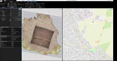
Georeferencing a 3D textured model of an excavation trench Reality Capture
Learn how to georeference a textured 3D trench model in RealityCapture and accurately align it within a GIS environment.
Read more