Introduction to Unmanned aerial systems

Author: Rohith Maben - Last update 2023-08-31
Aerial remote sensing is mainly carried out by manned aircraft at a high cost and with limitations that make its use unaffordable for everyday surveys. More recently, the use of UAS (Unmanned Aerial System) technology in archaeology has become more widespread, especially for mapping large sites or detecting features scattered in the landscape. In addition, the possibilities of combining and using various sensors encouraged the development of new investigation methodologies, with a major implications for field practice and knowledge production.
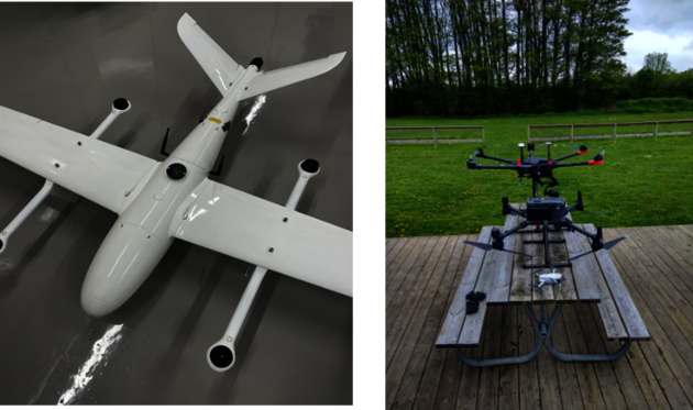
Multicopters (known as multi-rotors) often use fixed-pitch propellers, so the control of vehicle motion is achieved by varying the relative speed of each motor. Radio-controlled multicopters are increasingly popular for aerial photography and land surveying. The number of motors and configurations impacts flight performance, and each has advantages. For instance, the more motors, the more power and lift capacity, which means you could carry more payload. More motors also mean better redundancy in case of motor failure.
The fixed wing has the most extended range over any of the other categories. However, the downside to this platform is the requirement for a runway during landing or takeoff. UAV manufacturers are currently resolving this issue by developing fixed-wing aircraft that can take off vertically and transition to horizontal flight. This type of fixed-wing aircraft has Vertical Takeoff and Landing (VTOL) technology.
How to select a sensor and platform for aerial missions?
Measurements are critical for unmanned vehicle motion and carrying out the mission for which it is called to work. The sensors used to collect the data required by unmanned vehicles to operate can be very different regarding their technology and performance, with additional measurement accuracy capabilities needing to be considered. Increasing the autonomy level of unmanned vehicle functioning also increases the importance and the number of required measurements. The application range for these systems continuously grows in number and complexity, requiring new measurement capabilities and methods.
The type of payload used on a UAS affects the overall system performance. Therefore, the payload must have a low SWaP (size, weight, and power requirements.) The larger the UAS, the more fuel or battery power it can have on board. The more power the UAS can carry, the better the range and endurance. The range of a UAS is an important performance characteristic. It depends on several basic aircraft parameters and the weight of the payload. Maximum UAS range and endurance can be achieved with high propeller efficiency, low fuel consumption, and large onboard fuel (or battery power) capacity. A project that requires long hours in the air will need a larger UAS. However, most UASs employed for geospatial mapping purposes nowadays have an endurance of 90 minutes.

